| Saturday was the second day in a multi-day plains run. This day was forecasted to be better than the last with better moisture return, higher instability, and an upper level trough more established over the dryline. The models had a dryline bulge forecasted to surge eastward in the early evening across central SD. I targeted just ahead of this bulge for storms to fire and then move northeast towards an east-west warm front draped across northern SD where directional shear would be maximized for tornadoes. |
 |
I slept in my van just north of the town of Lusk, WY after yesterday's chase through eastern WY. I awoke to thick foggy skies, which got me down as I was hoping to take in the Black Hills and Badlands scenery in South Dakota. |
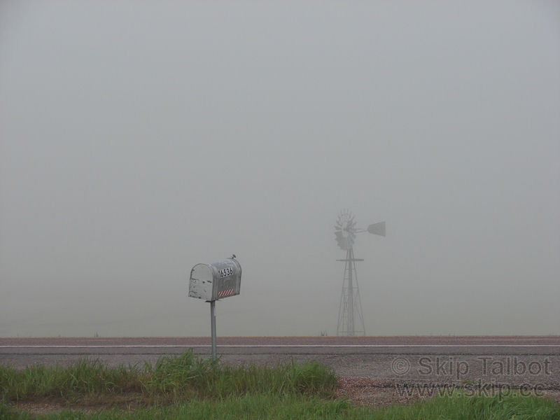 |
| I had apparently spent the night at Reed's place. I waited for the sun to start breaking through the fog before I departed heading east into South Dakota. |
 |
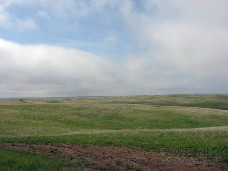
| I made my way through the Black Hills near Hot Springs, SD. The fog had lifted quickly after I departed and the low clouds were starting to break up as well. |
 |
| Southeast of Hot Springs in one of the most remote and empty places in the Great Plains, on the western border of an indian reservation, I got a call from Brandon Sullivan. I told him where I was and my thoughts for the day and then asked him where he was. "Right behind you!" I turned around, and sure enough a black SUV was right behind with Brandon and Brad Goddard. We stopped for a moment to discuss the plans for the day and decided to team up. Treeless rolling grasslands of South Dakota: |
 |
| I'm not sure what was going on with this guy's tires, but it was a pretty funny sight. |
 |
| Our route towards Pierre took us right through the Badlands. The area is pretty desolate and bleak and marked by large rock outcroppings and little knobby bumps. We stopped for a few shots: |
 |
More Badlands, scenery. The area is very beautiful yet the lack of roads and mountainous outcroppings make for terrible chase terrain.
We had been trying to find a place to get lunch, but South Dakota is so sparse we really didn't see anything at all. Finally we came to a gift shop/gas station at the end of the Badlands park. I saw Bison meat hot dogs there. "Well, that's fitting since I'm in South Dakota" I thought. I got one, and little did I know that it would come back to haunt me later that evening (dropping it on the floor of my grubby van didn't help either). |
 |
| We got on I-90 and started heading east. The Badlands gave way to rolling grasslands again. To a storm chaser this site is almost surreal. Mostly flat, treeless terrain as far as the eye can see. Its like a sailor looking out across the sea. |
 |
| We meandered through Pierre, the capitol and a pretty town surrounded by large green hills. North of there we met Kevin Crawmer who was sitting on the side of the road awaiting initiation. We were soon joined by Zach Chappell and his girlfriend, who was on her first chase. We had a bunch of meager looking cumulus to our north. It was hot and muggy, and we could see the dryline surging in from the west with clear skies except for just a little cirrus. It was starting to look like a cap bust. I joked with the group about how yesterday was like June 5, 2009, being upslope flow over the same areas as last year, and that would make today June 6, 2009, which was a cap bust. The cu started to drift away to the north leaving us in clear skies, to so we went north following them. |
 |
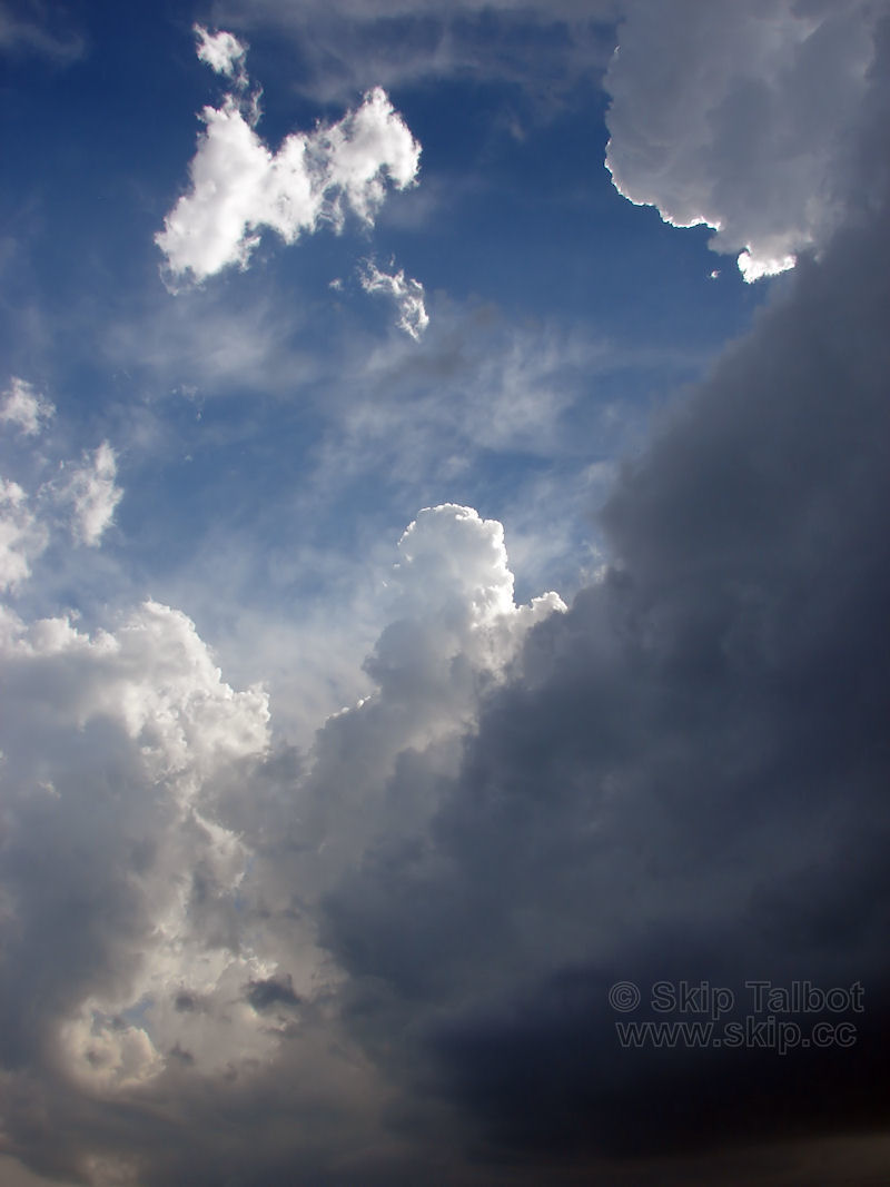
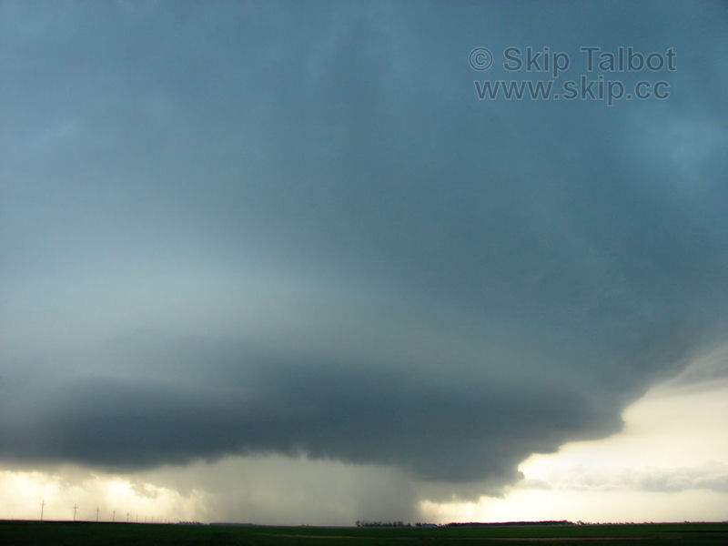
| As soon as we departed the cumulus started to take off and shot up into the air in big towers. The towers were going up so quickly they had pileus caps above them, smooth laminar shaped clouds that are formed when air is rapidly forced upwards, in this case by the towers pushing up so rapidly. We had a good visual on the rain free base below the tower and we pulled off near some intersecting highways where other chasers had congregated to let the storm mature. Within minutes a tornado watch went up and the storm was tornado warned. We had gone from puffy little cumulus to a tornado warning in about a half hour, which was absolutely amazing. |
 |
| The storm started to develop a horseshoe shaped cut through it. A rear flanking downdraft was punching through, which is one of the precursors to tornadogenesis. |
 |
| Looking up and to the southwest as towers continued to go up on the flanking line of the supercell: |
 |
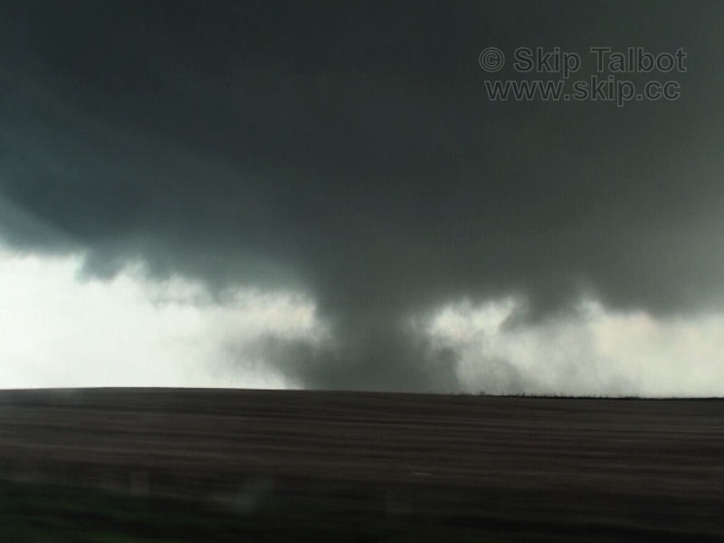
| This nub shaped lowering was weakly rotating and one of the storm's first attempts at producing a tornado. The meso above it with a smooth, striated base, was also rotating with good left to right motion noted. |
 |
| The initial mesocyclone looked like it was occluding and a new one forming off to the northeast. Scud started to rapidly condense as the storm developed a wall cloud. Our storm was cycling, and things were looking more and more promising! |
 |
| We moved north and east to follow the storm and stopped where we had a great view of the now fully formed wall cloud. There was rapid churning motion on the end of it and the inflow tail on the right continued to develop. |
 |
Looking up at the rotating base of a wall cloud:
We were quite close and had amazing contrast. If a tornado had been produced right then we would have had an incredible view of it. The structure on this supercell was some of the best that I had ever seen, and it just kept getting better and better. I remarked to the group that if this storm doesn't produce a tornado, I don't know what would. |
 |
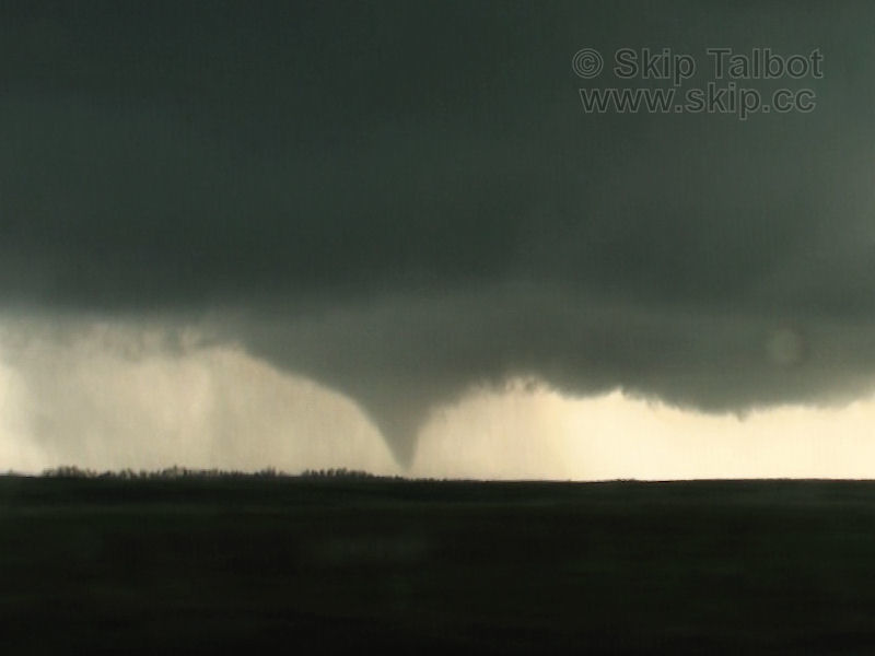
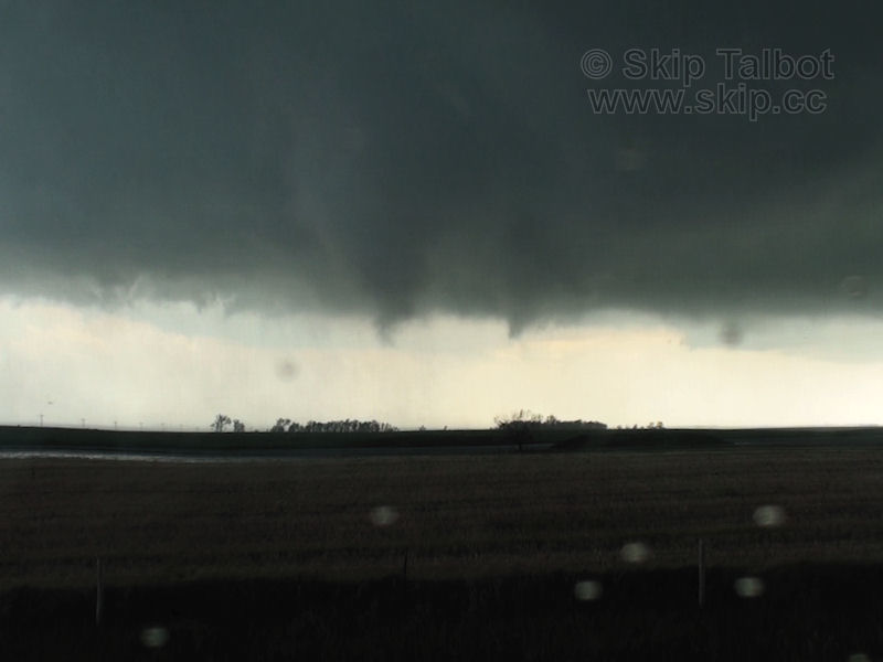
| We were on a gravel road and the plan was to stair step staying ahead of the storm. The eastern road option that Brad had picked out turned out to be a couple of muddy ruts running along a line of powerlines as a maintenance road. We couldn't take it, and would have to continue going north to the next east option. With Reed Timmer's dominator behind me, we proceeded north, driving right underneath the rear flanking downdraft and clipping the forward precipitation core. I was worried that we were going to get cored. Off to our southeast, Brad noticed a lowering with motion on the leading edge of the wall cloud. We finally made it up to highway 12 and turned east and our first tornado of the day quickly descended. |
 |
| We continued east a few miles looking to get ahead of the storm a ways. Atop a hill I had an elevated view of where the tornado was tracking and could see white swirls of rain and condensation where it was moving through a field: |
 |
| We were about even with the tornado and pulled off to shoot pictures. The condensation funnel started to retreat, but there was very much still a tornadic circulation on the ground. The Dominator pulled in behind us and Timmer jumped out, shouting commands to the rest of his team and excitedly describing the storm. He was putting on a show almost as much so as the tornado. |
 |
| Twin funnels. The one of the left was the original tornado and had rotated around to the northern side of the wall cloud while a new one was forming on the southern side. |
 |
| Brandon Sullivan shooting the funnels, with the Dominator and Reed Timmer's crew behind: |
 |
| The second funnel orbits around the larger scale circulation of the mesocyclone and touches down as a brief tornado with a visible debris cloud. |
 |
| A third tornado formed very, very rapidly, fully condensed within a second. It was moving rapidly northeast, which would put us behind it and cross our highway. We had to get ahead of it before it made that crossing or we'd either be trapped behind its trail of debris, or worse caught inside of it. |
 |
| We raced east while I continued to film the tornado with the robotic camera dome. The tornado morphed into a stovepipe shape with a large debris cloud being funneled right into the bottom of it. |
 |
| The tornado continued to expand into a large dusty debris cloud, reaching out to get us. Brad started shouting on the radio that we had to punch it east. I floored it. My video cut out briefly as the wind noise tripped the shock sensor on my camcorder. We made it out ahead of the the tornado which became a very broad, loosely defined circulation on the ground. |
 |
| Stopping briefly to look behind to the west. The dust swirls on the ground in the background are the tornado that we raced across the highway, and were the beginnings of a massive wedge tornado. Brad (left) and Brandon (right) getting ready to get back on the road so we can stay ahead of the tornado (background): |
 |
| We turned north on the west side of Bowdle, SD and then, not liking how the road continued unpaved north of town, we drove through town to get to our next north road. The sirens were wailing and people were standing out in the street looking around. The clouds above were churning violently. When we made our north turn, sirens still wailing, we saw it. A massive wedge tornado, wider than it is tall, had formed. A black speck on the right side of the tornado is probably a large piece of debris lofted into the air by the massive tornado. |
 |
| The scene was unreal. The storm was a churning corkscrew that looked like it had been literally carved by the downdrafts and inflow winds. Beneath it, the tornado spun amazingly fast. The motion was unlike anything I had ever seen before. |
 |
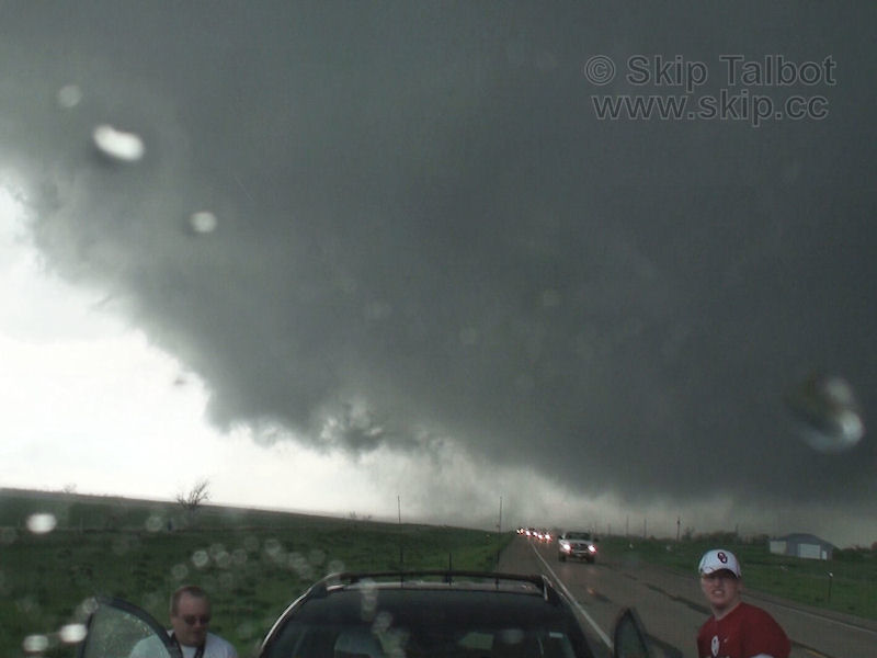
| We got right in front of the monstrous beast and stopped for a moment to get pictures and video. Brad radioed and had us plotted to follow gravel roads north and east to keep ahead of the tornado and maintain our view of it. The tornado was taking a right turn, however, and moving almost due east now it appeared. Without replying I turned the van around and started heading back south towards the highway, not wanting to gamble with gravel roads and such an epic tornado on the ground. Brad got on the radio, "Good call Skip!" |
 |
| We dropped a couple miles south to get out of the path and let the tornado pass us to the north where we stopped for more pictures. The funnel was no longer smooth, and laminar, but had become churning and chaotic with incredible left to right motion indicating violent rotation. I could tell just by looking at it, that this was a very, very powerful tornado, capable of inflicting incredibly destructive force on anything it hit. I have always been a fan of getting that photogenic rope tornado out in a field by itself, more so than a large, low contrast or rain wrapped wedge. This wedge, however, was both over open terrain and very high contrast. This is the most amazing sight I have ever seen while storm chasing, and will probably remain so for years to come. |
 |
| I'm not sure how far the tornado was from us. It was very large and hard to judge distance. It could have been a mile, maybe half a mile, either way it was as close as I wanted to be to a violent tornado. As it passed just to our north, I could hear the thunderous roar. It sounded like a giant waterfall, like Niagara Falls. My ears also started to pop as the pressure dropped with its approach, something I had never experienced before. It was here that disaster struck Kevin Crawmer. His car started billowing smoke from under the hood. It couldn't have picked a worse possible time. People were frantically shouting on the radio that we had to get south and get Kevin into another vehicle. We dropped south of Bowdle, Kevin ditched his car, grabbed his phone and camera, and jumped into my van. |
 |
| With Kevin loaded into the van, we continued our chase and blasted east down highway 12 to get back out in front of the storm. Lots of chasers were starting to show up now and were congregating on the highway. We kept ahead of the storm a a few miles trying to stay one step ahead of the crowd and also transitioning into more a structure chase as the storm looked like it was shifting into a high precipitation mode. However, the storm cycled, an RFD cleared out the rain from under the storm, and a funnel started to drop. Before we hit our north road option, we pulled off on highway 12 to shoot the developing tornado. A rope/stovepipe nicely backlit and surrounded by incredible supercell structure, striated mesocyclone (top), RFD core (left), and inflow tail (right): |
 |
| The funnel seemed to lift, but overall maintained a stocky tube shape with dancing tendrils whipping around on the underside. |
 |
| The funnel almost completely retreated before it fully condensed again, this time with more of a visible debris cloud underneath. Minutes after seeing the most epic tornado that we could imagine, we were treated to an extremely photogenic tornado framed by amazing supercell structur4e. Everyone was completely blown away at this point. The chase wasn't over but we were starting to celebrate. |
 |
| The tornado dissipated and rain started to fill back in as the storm transitioned into an HP mode again. A pointy funnel formed under the base with a lot of rapid motion. Although we couldn't confirm it at the time, this was our sixth tornado of the day as other chaser video shows a debris cloud under this funnel. The storm continued to cycle, transitioning back into a classic mode as the rain would clear out from under the base. Usually a storm stays in an HP mode once it makes that transition and begins to die. This storm would not stop, however. |
 |
| It was about this time that disaster strikes my friends and fellow Chicago chasers Adam Lucio and Danny Neal along with about 20 other storms chasers. They had routed themselves to follow the storm on gravel roads. The road abruptly ended even though the mapping software said it continued another mile where they could then drop south. With tornadic circulations immediately behind them, the situation became desperate and life threatening. The chasers turned south, and started driving across a planted field, where they all proceeded to get stuck in the mud. Tornadoes passed within feet of their vehicles, but they all made it through the barrage of wind, rain, and hail unscathed. They were all incredibly fortunate... until the farmer saw his field that is. |
 |
| Meanwhile, Kevin and I with Brad, Brandon, and Zach close behind continued east down 12 where we would go up a county road a couple miles to get some structure shots before dropping south again and repeating. Our route kept us safe but cost us a view of some of the tornadoes the others saw. East of Roscoe we met up with Steve Polley and crew and stopped for one last gander at the storm which now looked like it had transitioned permanently into an HP mode and was now starting to gust out. |
 |
| With the storm starting to become disorganized, and after our incredible catches, we decided to call it a chase and drop south to get out from under the storm where we'd head back west to get Kevin's car. Back on highway 12 there was a massive chaser congregation with seemingly hundreds of vehicles moving east down the highway. It took us a couple minutes just to get across the highway where we could continue going south and I was worried that the storm would core us as we waited. We made it across between gaps in the traffic, however. We headed back west after dropping south hoping to punch through a gap between the supercell we had been chasing and a squall line that was forming to the south. The gap closed in a little, however, and we got some wind, rain, and hail but nothing too severe. |
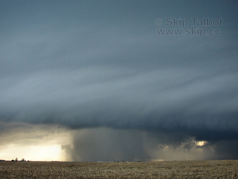 |
| We did pass power poles that looked like they had been snapped in half. We couldn't tell if that was from our storm, possibly the rear flanking downdraft, or if it was older damage as it was too far south to be from the tornado. The gravel roads held up although we hit some ruts that made the van bottom out and some mud that caused some fishtailing. Zach was able to follow no problem behind us in his car, with his girlfriend a little shook up after all we had seen and done. We got back out into sunny skies near Bowdle and found Kevin's car intact. Brad and Kevin were able to get it running and we headed south towards Pierre where we said our goodbyes and departed for the night. |
| The bison meat hotdog I had eaten in the Badlands earlier caught up with me that night as I tried to sleep in the van east of Pierre. I rolled around sick to my stomach all night before Adam called me at 2:30 am. Their vehicle was still stuck in the farmer's field. They had gotten a ride out of there but were stranded at a gas station with no power. More than an hour to the south, and not feeling well, I wouldn't be much help. They finally got a hotel room in Aberdeen that night, but the farmer, irate at all the vehicles in his field, called the police, held the vehicles there for hours, and wound up charging them each $400 for damages to his field. |
|
| Conclusion:
This was by far my best chase to date and also my first time in South Dakota. The terrain was amazing in the north central part of the state, the data and grub joints sparse, but the road network surprisingly good. Not only does this chase have my highest tornado count to date, but each tornado on this chase lasted several minutes, was high contrast, and very photogenic. The wedge tornado was also the most incredible thing I have ever witnessed. Seeing a violent tornado at such close range while hearing the roar and having my ears pop was just awe inspiring. The tornado was rated EF4 and thus by far the most powerful tornado I had ever seen as well. It took a large metal transmission tower, pulled it out of the ground, and lofted it hundreds of feet. It also hit a few farm steads but luckily did not hit any towns like Bowdle or the damage could have been far, far worse. Our storm was one of only a couple tornado producing supercells of the day, and will probably be the storm of the year. It was also very special to me to be able to catch this storm from its birth as cumulus. I had only done that a few times in the past, and never with a tornado intercept, let alone my best chase ever. The whole chase was captured with the robotic camera dome, from the birth of the storm as towering cumulus to its death as an outflow dominant high precipitation supercell, and several tornadoes in between including an extremely powerful wedge. The perfect chase.
|
| |
|
Lessons Learned:
- Don't gamble with gravel roads and mapping software with a tornado behind you.
- Don't eat bison meat hot dogs from Badland's gas stations.
|
|
 |


