Statistics:
| Initial Target: | Childress, TX |
| Departure: | Childress, TX 3:00 pm |
| Arrival: | Orlando, OK 10:30 pm |
| Intercepts: | Alanreed, TX |
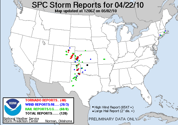
| Tornadoes: | 5 |
| Hail: | None |
| Wind: | Non-Severe (not measured) |
| Features: | Tornado, funnel, wall cloud |
| Miles: | 422 |
Summary:
| Dryline/Upslope play in the TX panhandle. Waited for initiation with several other chasers in Childress, TX. Departed for initiation southeast of Amarillo, intercepting north of Clarendon on highway 70. Noted cycling supercell with two large, cone tornadoes. Followed storm north of Alanreed where it gusted out. Dropped back down to highway 70 to intercept strengthening southern storm. Intercepted wall cloud and followed storm north of Alanreed noting two, brief RFD gust front tornadoes. Fled south trying to beat RFD core while passing relatively close to multi vortex tornado. Called chase over when back on I-40 as storms lined out, making for OK to setup for next day's setup. |
Crew and Equipment:
Solo chase. Equipment: Kenwood TH-F6A Tribander, Dell Inspiron Laptop. Kyocera data card and router, Holux 236 GPS, Robotic camera dome with Sony XR-520V.
|
Video:
Details:
| This was the second day in a three day plains marathon chase run. Yesterday had some pretty weather, but I didn't drive all the way to Texas for rainbows. Its probably too much to expect a tornado on any given chase, but I expected to bag at least one on the trip, and this day looked like the best shot. |
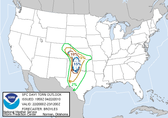 |
There were similar conditions to that of the day before, except the trough would now arrive in earnest, providing the needed wind shear to sustain supercells. The dryline was also forecasted to be much more well defined with moderate instability. The morning clouds pushing off and cap eroding by early afternoon indicated that storms were expected to fire by mid to late afternoon down the length of the dryline. A moisture tongue with dewpoints approaching 65 was nosing in from the southwest in the Childress area. Combined with the favorable shear profiles across the entire Texas panhandle, Childress became my primary target. The night before, however, the models really highlighted northwest Kansas. Along the warm front the directional shear was supposed to be maximized with still moderate instability. The morning RUC and NAM both pointed back at the Texas panhandle, however, and Kansas was completely socked in with clouds so the Childress target stuck. Although points north still did have favorable parameters, and would erupt with tornadoes later in the day. I had met up with chasers Adam Lucio, Danny Neal, and Mike Nelson the night before in Childress after yesterday's chase. We agreed to split a room for the night, which would be a nice change from sleeping in the van. However, between my indigestion from the dive 24-hour diner across the street, Danny's incredibly loud snoring, Mike's swearing in his sleep, and Adam's bizarre noises that sounded like a train (he literally went "WOOO WOOOOO!" in his sleep), I couldn't sleep a wink in that hotel room. I wound up leaving and sleeping in the van in the parking lot. |
|
After getting breakfast at the same greasy diner, we stayed in the hotel parking lot all day waiting for initiation. Other chasers started to file in. While waiting, a woman showed up with her two kids, one sporting a "Future Storm Chaser" t-shirt. After getting his picture taken in front of the van, the mom had him tell me what his favorite movie was: "Twister," what he wanted to change his name to: "Bill," and what he wanted to drive: "Dodge Ram truck... red." Amazing, I hope my kids turn out just like him. I asked the mom if they were chasers and she said, no, she was just out to find the storm chasers for her son. "Today we are chasing the chasers!" She had found us. |
 |
| Impatience turned to outrage. Colorado and Kansas were lighting up with supercells that were producing multiple tornadoes. Maybe we should have gone after that Kansas target after all. Maybe we should always just play Colorado whenever there is a big plains setup. Maybe we should stop trying to predict the weather entirely. We sat under a low level cloud deck, waiting for clearing so the atmosphere could destabilize along the dryline. |
 |
| The clouds cleared out by mid afternoon and a tiny blip showed up on the radar between our location in Childress and Amarillo. Everyone cleared the lot and we were off! I raced northwest up 287 for the intercept. Behind the puffy little cumulus in this shot, you can see the storm, just starting to form an anvil way out on the horizon: |
 |
| I went north out of Clarendon on 70 with the intent of letting the storm come to me and giving it some time to get its act together. I found a dirt road a couple miles off the highway that had a nice view to the southwest. The storm went severe warned. I could see the base, but it was so far off (probably 15 miles) and hazy that my view of it was terrible. I got impatient waiting for the storm to come closer and decided that I needed to see the base now for fear of missing something. I ran back south down 70 to Clarendon and then northwest up 287. |
 |
| The base came quickly into view with a wall cloud starting to form. The storm was already moving off to the north though which meant I could no longer wait in one spot for it. I had hoped to take the highway north out of Goodnight, TX but the storm had already crossed that highway, which meant I had to turn around and go back the same way I came, southeast down 287 away from the storm and back up 70. I was going to be well away from the storm with my back to it for several minutes. I prayed nothing would happen while I raced to get back to the same spot I had been earlier before my impatience got the best of me. |
 |
| Racing north on 70 at 85+ mph behind a another chaser (I could tell because he was also going 85+), a big bowl shaped lowering came into view. Even though it was a few miles out, I could tell that it was a large funnel. |
 |
| I continued to race north trying to get closer and get a better view (even though it was quite good already where I was). The funnel tightened into a pencil shape. I passed hordes of chasers parked along the sides of the highway. |  |
| The funnel stretched out for the ground but never fully condensed. Generally speaking you need a debris cloud on the ground to confirm a tornado, but for most chasers if a funnel extends more than 3/4's of the way to the ground its typically counted as a tornado as more than likely there is an associated circulation at ground level. That was enough for me. My first tornado of 2010! Other chasers did also confirm there was a ground circulation earlier in its life as it was forming under the wall cloud. The tornado quickly roped out after I shot this picture, so I continued north. The wall cloud pictured on the right (and extending out of the picture) was ramping up and I wanted to get parallel with it for the best contrast. |  |
| Moments after the first tornado roped out into nothing, a funnel quickly developed beneath the center of the wall cloud. There were hills in front of me, but this funnel had much more apparent ground contact. Tornado #2! I continued north looking for a good spot to watch this one. |  |
| Clear of the hills I had a great view of the ground the tornado was moving over. A large debris cloud swirled about underneath the tornado. My heart raced with excitement as I watched. What an amazing chase, and it had barely just begun. |  |
| I found a flat, green plain with wide gravel shoulders. A perfect spot to pull over. I pulled in with several other chasers that had already parked there, and watched the rest of the tornado's life span. The cone funnel hung just above the ground for most of its life but a few times it reached out. The wall cloud around the tornado dissipated and reformed to the NE with the tornado moving along the storm's gust font. A new circulation started to develop and resulted in a brief rope funnel (right) next to the larger cone tornado (left). Two circulations at once, amazing! |  |
| The circulation associated with the rope funnel did not appear to touch down before it dissipated. I shot a few close ups of the main funnel. |  |
| The tornado starts to rope out in a similar fashion as the first tornado: |  |
| The funnel made one last stretch for the ground but never quite reached it, before continuing to rope out into nothing. |  |
| Highway 70 ended a mile up the road where it hit I-40. I would have to find a new north road to pursue the storm. I went east on 40 to the town of Alanreed where a highway went north through the caprock canyons. After passing over and around several large hills, I found a great spot to pull off the road and view the storm. Pictured here is the storms updraft tower (top), forward flanking precipitation core (right), updraft base (center) with inflow band (extending right), rear flanking gust front (left front) and rear flanking precipitation core (left rear). |  |
| While I was watching the storm I saw the entire Discovery Channel caravan fly past me heading north into the forward flanking core. Reed Timmer in his Dominator and Sean Casey in his TIV2, both painted as bitter rivals in last season's Storm Chasers show, passed in short succession. A line from Ghostbusters popped into my head: "Dogs and cats living together... Sean and Reed chasing together... mass hysteria..." The rear flanking gust front continued to bow out into what looked like a massive high precipitation supercell, which would be difficult to chase and obscure any further tornadoes. Meanwhile a storm that had been struggling on the southwest flank of this one was finally getting its act together, had gone tornado warned, and was exhibiting a nice hook echo. |  |
| Adam, Danny, and Mike caught up with me and we exchanged a few brief words before we both concluded it was time to bail on this storm and head south to the next one. Heading back south towards Alanreed, the dome got a glimpse of the storm we were after, some thirty miles out on the distance. |  |
| Contrast enhanced there is a distinct cone shaped lowering under the base (backlit on the left). This might have been one of the tornadoes the storm produced near Goodnight, TX, but at that incredible distance there is no way I could ever confirm this is a shot of it. |  |
| Back on 40 I raced east to greet the storm head on. A nicely backlit base with a big wall cloud came into view. I exited too late and wound driving right under the wall cloud, which is a precarious position to be in. Luckily the wall cloud didn't put down a tornado and I was able to turn around and get west ahead of it. |  |
| I wound up going north out of Alanreed, on the same road I was just on, to keep up with the storm. While going east on I-40 the rear flanking precipitation core fanned out under the base and I was worried it was gusting itself out and the chase might be over. There was still strong rotation in the base as the gust front moved from left to right, however, so I decided to keep up with the storm. North out of Alanreed, a classic wall cloud (right) came into view. Behind it on the rear flanking gust front, what looked like a funnel started to descend (extreme left). |  |
| I was driving over and through the hilly canyons at the time and didn't have a spot to pull off the road. I managed to snap this picture with the camera over my left shoulder of the funnel as it continued to descend. I couldn't confirm it at the time, but this was tornado #3 of the day. |  |
| A classic wall cloud with tail cloud feeding into it from the right: |  |
| I reached the pull off where I had stopped originally on the first storm. Here I got a view of tornado #4 (just left of the tree), a brief, rain wrapped funnel on the southern flank of the wall cloud. There was only one car sitting here this time whereas more than a half dozen had earlier. As I saw how close the forward flanking core was I quickly realized I was in a terrible position. This storm was much further east relative to the highway than the last storm and was moving directly for me. I would have to flee south immediately or I would wind up in the tornado producing part of the storm or in the rear flanking downdraft precipitation core with severe wind and hail. |  |
| I raced back south to get out from under the storm. Ahead of me the rear flanking core was fanning out and starting to cross the highway up ahead. I wasn't going to make it. Just as I realized this, a tornado spun immediately off my right. I swung the robotic dome camera over just in time to capture it. The funnel was small and skinny and didn't last long. |  |
| It roped out as quickly as it came, but another one took its place immediately behind it, both orbiting about the same point. Tornado #5 was a multi-vortex tornado. The parent circulation was large but relatively weak. Each one of these sub vortices could pack a serious punch, however. |  |
| There was no time to stop. I still had to race the core of the storm south, in addition to a multi-vortex tornado. I started to clip the edge of the core with blasts of wind and rain hitting the van. My heart almost stopped at the thought that I might not clear the tornado or there might be others hidden in the core. The robotic camera dome looking northwest and behind at the tornado (left) as I race south into the core (just off the left side). |  |
| I cleared the bulk of the core of and made it onto I-40 where I could run east to keep ahead of the storm. I looked behind me and saw a scene that reminded me of the end of the movie Field of Dreams. An entire line of headlights, dozens and dozens of cars on a normally empty highway in rural Texas, each one of them a chaser coming out of the storm. Not all of them were spared the storm's wrath. One chaser had his entire rear windshield smashed out by huge hail. |  |
| Heading east on I-40 it was quickly becoming apparent that the line of storms was lining out into a massive squall with embedded supercells. Minutes after seeing my fifth tornado of the day, I called it a chase and started heading east for Oklahoma. There was a lone supercell raging just south of my original target of Childress. I knew it would be close to or after dark before I intercepted, and it would put me further away from the next day's target, so I let it go. The storm wound up producing a gigantic, yet rain wrapped wedge tornado. | |
| I was hoping to meet up with Adam, Danny, and Mike for celebratory steak dinner, but they stayed behind chasing the squall line so I continued on towards my target for the next day. I stopped for the night on a gravel road outside the small town of Orlando, OK and had a few granola bars and some beef jerky for dinner. It was a nice spot until a squall line hit in the middle of the night and I woke up to potentially severe winds rocking the van. I fired up the laptop to check out the radar and get a reading from the roof mounted anemometer, but I didn't have all the necessary software setup. | |
| Conclusion:
This was my best chase since March 28, 2007, a day in which I also saw five tornadoes. These were my first Texas tornadoes and my first April tornadoes since 2007. At what was probably less than a mile, the multi-vortex tornado north of Alanreed was the closest I have been to a tornado since the Waverly, IL tornado on May 30, 2008. While the Colorado and Kansas targets were also prolific tornado producers, I believe the Texas tornadoes were the most photogenic. The most photogenic tornadoes of the day were near Goodnight, TX and came out of the southern storm that I arrived late on (but still caught three tornadoes out of later). The wedge tornado between Childress and Paducah was amazing, and quite close to my original target. I'm glad I went north, however, since I'd prefer to see more tornadoes and photogenic tornadoes rather than one large rain wrapped wedge. With five tornadoes I had topped my count for the entire 2009 season in one day. Amazing.
|
|
|
Lessons Learned:
|
|
|
|
|