Statistics:
| Initial Target: | Effingham, IL |
| Departure: | Bolingbrook, IL 8:00 am CDT |
| Arrival: | Bolingbrook, IL 10:30 pm CDT |
| Intercepts: | Newton, IL |
| Tornadoes: | 0 |
| Hail: | None |
| Wind: | Non-Severe (not measured) |
| Features: | Bowing segment with embedded circulation |
| Miles: | 558.0 |
Summary:
| Rendezvoused with Andrew Pritchard and Scott Kampas in Urbana. Ignored line of tornadic supercells over Ohio River and lower Indiana due to terrain/flooding. Waited for second line of supercells to organize over western IL. Left Urbana at noon targeting Effingham. Second line did not tornado as the first did, undercut by a rapid moving cold front. Intercepted severe warned bow echo on northern end of line just north of Newton. Tight couplet observed on radar just prior to tornado warning. Despite close proximity to circulation, no tornado/condensation funnel was observed due to heavy rain. Mammatus and double rainbow observed as storms passed into Indiana. |
Crew and Equipment:
| Chase team included Andrew Pritchard and Scott Kampas. Equipment consisted of a TH-F6A Tribander, and GPS/Cell Phone equipped laptop. Photography by Skip Talbot. |
Details:
| November had been unusually active for severe weather in the
Midwest. After chasing on the fifth, there was a favorable setup in
northeastern IL on the ninth, and then a tornado outbreak in
central Iowa on the twelfth. The setup on the ninth busted due to lack of CINH erosion,
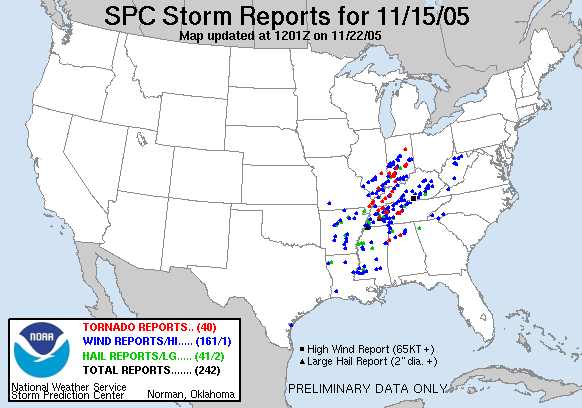
however. The year was going to go out with a bang. The weather models brought a screaming jet over the Ohio river valley. Speed shear over 80 knots and 1km SRH values over 500 in southern IL. The models were not forecasting much instability. However, the strong dynamics of the system were forecast to overcome the lack of daytime heating. SPC went with a high risk for the 15th, the third high risk of the year, with a 25% hatched tornado from northern Arkansas to central Indiana. |
 |
| With excessive amounts of shear, the storms were
forecast to be moving extremely fast and over the poor terrain of the Ohio
River valley. Ongoing storms from the prior evening and morning of the
event meant much of the area would be flooded as well. Although the
area was primed for a large tornado outbreak, it would not be an easy chase. You don't pass up a November high risk in your home state though. Always low on cash, I borrowed a credit card from the folks and then made plans to rendezvous with Andrew and Scott to split the gas costs. Dewpoints were only in the upper 40's that morning but a deepening surface low, forecasted at 988 mb over central IL at 0z, would rapidly advect moist air from the south. We targeted Effingham since it would be close to the surface low, on the warm front, and has a good road network if we needed to adjust. Waiting at Andrew's house in Urbana, Scott caught up with us. PDS tornado watches were being issued until the the entire mid Mississippi/Ohio valley and into central IL was covered. A continuous line of training supercells was moving across Kentucky into Southern Indiana. We ignored this activity due to the terrain and flooding, expecting further development to the north. |
|
| As a second line of cells started to form over St. Louis we
jumped on 57 and headed south to Effingham. Complete disaster almost
struck as my laptop abruptly lost power and then refused to boot back into
Windows. We were back in business after resetting the BIOS settings
though.
We stopped in Effingham for data and met up with chasers Dave and Tzvika. The second line was not organizing into nice tight supercells, nor were other lines developing. Scott was working the radar and was not impressed with the situation. We sat and waited for the line to approach as the first line had nearly continuous tornado warnings along its length in southern Indiana. Dave and Tzvika got anxious and left, planning to intercept a severe warned cell on the northern end of the line. |
 |
| The bowing segment appeared to be the only game in town, so
we too made plans to intercept. We ran southeast toward Newton.
Scott noted a very tight couplet embedded right in the center of the
precipitation core. It broadened out by the next pass of the radar but
was still quite visible. Scott plotted us a spot just north of the
circulation. We drove
north of Newton, passing Dave and Tzsiau heading the opposite direction,
before pulling over to let the storm overtake us. As the heavy rain and winds came in, the weather radio sounded with a tornado warning. We were sitting dead center in it according to the polygon display on GrLevel3. Andrew and I got the video cameras ready but we couldn't see anything through the rain. After the chase a tornado report came in from Newton, made by the local sheriff based on damage. Highly skeptical we suspected it might just be straight line wind damage. However, an NWS damage survey team came out and did indeed find that it was a tornado. An F1 with a 10 mile path that passed just north of Newton. Scott plotted our position, and Dave and Tzika's, against the path of the tornado. We were within a mile of the circulation, Dave and Tzvika, much closer. Its lucky they weren't even closer as the tornado overturned a truck on that highway and brought down power lines. |
 |
| When the rain cleared and we had a view of the back end of the storm, we got back on the road. Scott routed us to keep up with the storm, but the couplet faded on the radar and the warning expired. We stopped near an entrance ramp to I-70 to assess the situation. The cells in Indiana were still going crazy with tornado warnings. Scott Weberpal called to tell us that he had briefly seen a tornado in southern Indiana, but his chase was cut short by debris in the road. Attempting to route around the debris, he stalled his car in a flooded section of road. |
 |
| As the cold front passed us, the sky cleared. The setting sunset fired a rainbow with a faint double rainbow. The back end of the storm, colored bright orange showed a hint of mammatus as well. Andrew and I took in the sight while Scott assessed our situation. Night was quickly approaching and we'd never catch the Indiana storms in time. The chase was over. |
 |
|
|
 |
 |
|
| We stopped for dinner at the Fridays in Effingham. The waitress asked us if we were out celebrating something. Scott reluctantly told her we were storm chasing. "Stormchasing???" She must have thought we were a bunch of nerds. |
 |
|
|
|
| Conclusion: We didn't get our line of tornadic supercells, but we did manage to get within a mile of an invisible tornado. There were several tornadoes, but November 15 was not a historic outbreak. A large wedge tornado touched down near Paducah and many in Indiana. Most chasers on the line in southern Indiana busted, however. They were either unable to keep up with the storms or got caught in the flooding as Scott did. We made the best of our situation however. Scott plotted us a perfect intercept of a storm with a confirmed tornado, but one that was impossible to see because of the rain. We made the best of what we had, and the high risk setup was an exciting end to the year. Lessons Learned:
|
|
|
|
|