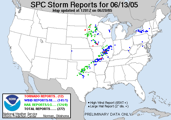
Statistics:
| Initial Target: | MO/IL border north of St. Louis, MO |
| Departure: | Edwardsville, IL 12:30 pm CDT |
| Arrival: | Bolingbrook, IL 10:00 pm CDT |
| Intercepts: | Jerseyville, IL |
| Tornadoes: | 0 |
| Hail: | Non-Severe (pea sized) |
| Wind: | Non-Severe (not measured) |
| Features: | Rotating wall cloud, double rainbow |
| Miles: | 359 |
Summary:
| Waited until initiation and when cells were near MO/IL border, not wanting to chase MO or near the river. Left Edwardsville at 12:30 headed towards southern cell in a line of discrete cells. Intercepted severe warned cell in Jerseyville, IL. Followed rotating wall cloud as storm was tornado warned. Storm exhibited rotation for over an hour but never produced a tornado. Finally abandoned cell when precipitation core enveloped the updraft, and to escape rapidly approaching severe squall line. Witnessed double rainbow later that evening after squall line passed. |
Crew and Equipment:
| Solo chase. Equipment consisted of a NOAA weather radio, TH-F6A Tribander, and GPS/Cell Phone equipped laptop. Photography by Skip Talbot. |
Details:
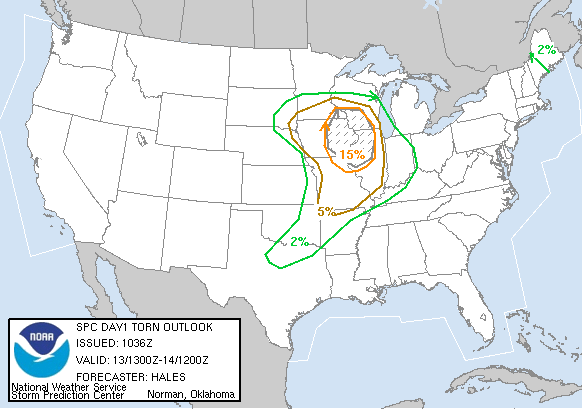
| After visiting Nick Lockwood for the weekend, the weather
set itself up for a chase on the way home. SPC issued a moderate risk
centering on the Quad Cities. I didn't quite agree with SPC, favoring
areas further south with better shear and instability. Not wanting to chase in Missouri or near the
Mississippi, I waited until a line of discrete cells went up near the river
and planned to intercept them once they crossed into Illinois. After
rigging the Shibster for the chase, I left Edwardsville at 12:30.
|
 |
| The GPS/internet laptop combination worked perfectly on this chase. I had almost a continuous connection until I intercepted. There were three cells crossing the river as I headed north. The northern most one had a tornado warning on it, but I opted for the southern most cell, which only carried a severe warning. It was a younger cell, and had a much better appearance on radar: A pendent shaped supercell with an unimpeded inflow. | |
| As I approached Jerseyville, the cell looked fantastic on
the radar. I got stuck behind small town slow traffic and was getting
really anxious to get past them and under the storm.
Finally I broke out of the town and the storm base came into a view, a wall cloud hanging from the bottom. I quickly located a spot to pull over and setup the tripod to shoot pictures. The wall cloud was definitely rotating, slowly, but surely. After shooting a few stills I pondered why this great looking supercell, with a couplet on the radar, and a rotating wall cloud, was not tornado warned. Right on cue the sirens sounded and the weather radio went off with a tornado warning. |
 |
| I stayed in my first spot for a few minutes until I realized
I was sandwiched between the wall cloud and the precipitation core. I
opted to move south about a mile and found the wall cloud moving
straight over my head. Intense cloud to ground lightning struck all
around me, with almost no delay between the thunder and the lightning.
Pea sized hail also started to fall. The combo forced me back into the
Shibster The southern portion of the wall cloud: |
 |
| The center portion of the wall cloud, heading straight for me: |
 |
| The northern portion of the wall cloud, scud feeding in from the precipitation core: |
 |
| I had blue skies immediately to my east. Cloud to
ground bolts were striking on the forward flank. The blue backdrop
against the lightning was an eerie sight.
|
 |
| I dropped further south to get out of the hail and from underneath the wall cloud. Looking up and south at the storm base: |
 |
| Past Jerseyville, I found a nice easterly option to parallel the wall cloud. I stopped for pictures every few minutes, still observing rotation. |
 |
| The wall cloud tightened up into a much more impressive shape. I passed a couple of locals who caught up with me when I stopped for pictures. I took a minute to explain to them what we were looking at, and had to convince that I was chasing just for fun, and not professionally. I ended the conversation abruptly, to keep up with the storm. The locals hopped in their pickup and tailed me for a mile or so until I lost them with a little speeding and some tight turns. |
 |
| In rural eastern Illinois, I found myself on Bob's road for
about half an hour. There were steep hills, twists and turns, but I
was able to keep up with the storm. The wall cloud had disappeared but
rotation was still evident in the base of the storm, and a strong couplet
still showed on the radar.
The scud featured in this photo dropped from the base and I thought another lowering might be forming, but it disappeared.
|
 |
| I followed this storm until the very end. It started
to disorganize on the radar, all the precipitation was just dumping out, and
a fast moving squall line was quickly enveloping it. One last picture, looking east at the precipitation core, before I said goodbye. |
 |
| I ran south hoping to catch interstate 55 before the squall
line hit. I didn't make it and pulled over to watch it come in.
I was just north of a bowing portion of the line, which had a nice couplet and was tornado warned. I cautiously continued south, making sure not to get caught in a rain wrapped tornado. |
 |
| North of Springfield, the squall line gave way to clear western sky, and a pretty sunset. A beautiful double rainbow formed across orange clouds and a purple sky, with anvil crawler lightning streaking by as well. What a pretty end to a successful chase. |
 |
 |
|
| Conclusion: No tornadoes, but still quite a successful chase after intercepting a rotating wall cloud and a picturesque sunset/rainbow. A tornado report did come in on this storm, but I don't believe any other chasers verified this. Other chasers on this storm: John Farley Darin Kaiser Lessons Learned:
|
|
|
|
|